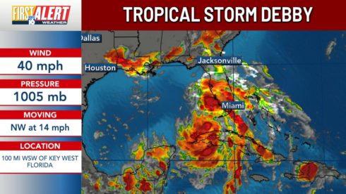
Tropical Storm Debby has emerged in the Gulf of Mexico, rapidly intensifying since its upgrade from a tropical depression on Saturday afternoon. As the storm moves towards Florida, it poses a significant threat with heavy rainfall, potentially life-threatening storm surge, and dangerous flooding. The National Weather Service (NWS) has issued warnings for various regions, anticipating that Debby may strengthen into a Category 1 hurricane by the time it reaches Florida’s Big Bend region early Monday morning.
The storm’s impact is expected to be severe, with southwestern Florida and the Florida Keys bracing for overnight tornadoes. Hurricane conditions could commence as early as Sunday night, with the storm expected to slow down, resulting in concentrated rainfall and increased flooding in affected areas. Beachfront communities along Florida’s Gulf Coast are already preparing for the storm, with city officials securing public infrastructure against the anticipated impact.
Forecasted Conditions: Rainfall and Storm Surge Warnings
According to the National Weather Service, Florida’s Gulf Coast could experience up to eighteen inches of rainfall and storm surge heights reaching seven feet through Monday. These conditions are likely to lead to significant flash and urban flooding, with major river flooding also anticipated. The NWS has warned that the combination of heavy rain and high storm surge could lead to widespread and dangerous flooding across the region.
In preparation for these severe weather conditions, various warnings and alerts have been issued. Areas under a Hurricane Warning include the Gulf Coast from the Suwannee River to the Ochlockonee River. A Hurricane Watch is in effect for the coast west of the Ochlockonee River to Indian Pass and east of the Suwannee River to Yankeetown. Tropical Storm Warnings and Watches are also in place for other areas, including the Florida Keys and the west coast of the Florida peninsula.
Tropical Storm Debby Alerts and Preparedness Measures
As Tropical Storm Debby approaches, residents in Florida are urged to take immediate action to protect themselves and their property. A Hurricane Warning is in effect for the Gulf Coast, signaling that residents should be ready for potential hurricane conditions. The NWS also issued Tropical Storm Warnings and Watches for various regions, including the Florida Keys and the western coast of the peninsula.
Storm surge warnings are in place from Aripeka northward to Indian Pass, with a Storm Surge Watch extending from Bonita Beach to Aripeka, including Tampa Bay and Charlotte Harbor. Emergency management officials, such as Jevon Graham in Clearwater, emphasize that storm surge and rainfall are the primary threats. Preparations are being made to mitigate the impact of flooding, with city workers securing essential infrastructure and residents advised to follow official guidance and prepare for extreme weather.
Understanding Weather Watches vs. Warnings
The National Weather Service (NWS) differentiates between weather watches and warnings to help residents respond appropriately to severe weather events. A weather warning, such as a Hurricane Warning or Storm Surge Warning, signifies an imminent threat to life or property. When a warning is issued, it is crucial for residents to take immediate protective actions, as severe weather conditions are expected to occur soon. The NWS emphasizes that “a warning means weather conditions pose a threat to life or property,” and immediate precautions should be taken to ensure safety.
On the other hand, a weather watch indicates that conditions are favorable for severe weather but the exact timing and intensity are not yet known. For example, a Tropical Storm Watch means that residents should prepare for the possibility of extreme weather, as meteorologists anticipate potential development but cannot predict precise details. According to the NWS, “People should have a plan of action in case a storm threatens and they should listen for later information and possible warnings especially when planning travel or outdoor activities.”
NWS Urges Caution as Tropical Storm Debby Approaches
Dr. Michael Brennan, director of the National Hurricane Center, has warned of the imminent threat posed by Tropical Storm Debby, which is expected to bring dangerous storm surges to Florida. The storm could strengthen to a Category 1 hurricane by Monday, making landfall along the Florida Big Bend coast. Brennan advises residents in storm surge evacuation zones to heed local officials’ guidance and prepare for evacuation if necessary. “Know if you are asked to evacuate, please know where you’re going to go, how you’re going to get there,” Brennan urged, stressing the importance of having a clear evacuation plan.
As Tropical Storm Debby approaches, it is anticipated to slow down, increasing the risk of severe flooding. The slowing storm will not only enhance rainfall but also elevate the potential for storm surges and strong winds. Brennan warned, “That’s going to exacerbate not just the rainfall risk, but also the potential for storm surge and some strong winds,” highlighting the need for vigilance and preparedness.
Florida Governor Declares State of Emergency
In response to the approaching storm, Florida Governor Ron DeSantis has declared a state of emergency for most counties across the state. The declaration comes as Tropical Storm Debby is forecasted to intensify into a Category 1 hurricane, potentially impacting a wide area of Florida. Governor DeSantis’s action aims to mobilize resources and prepare communities for the storm’s impact, ensuring that necessary measures are in place for public safety and emergency response.
The storm’s potential to bring tornadoes, especially to the Florida Keys and southwestern regions, adds to the urgency of the situation. Dr. Michael Brennan noted the risk of tornadoes associated with the storm’s rain bands, emphasizing that “We do have the risk for tornadoes and some of those rain bands, especially later today and into tonight.” Residents are advised to stay informed and adhere to safety instructions as Debby approaches and strengthens in the coming days.


