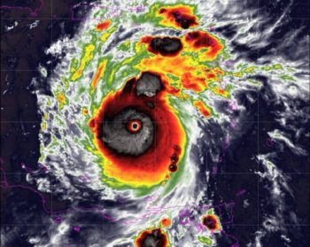
Hurricane Beryl has been officially upgraded to a Category 5, signifying a potentially catastrophic impact, according to the National Hurricane Center’s announcement on Monday night. This upgrade comes as maximum sustained winds reached a staggering 160 mph, as confirmed by the National Oceanic and Atmospheric Administration (NOAA) Hurricane Hunters. This significant intensification underscores the severe threat posed by Beryl as it continues its path across the eastern Caribbean Sea.
The hurricane, which initially slammed into Carriacou Island in Grenada with winds of 150 mph as a Category 4, has left a trail of destruction in its wake. Local officials have reported at least one confirmed fatality, with Prime Minister Ralph Gonsalves indicating the possibility of more casualties. The storm’s rapid intensification and destructive potential have raised alarms across the region, prompting widespread preparations and evacuations.
Devastation Across the Grenadine Islands
Beryl’s impact on the Grenadine Islands has been severe, with extensive damage reported across various islands. Union Island, in particular, has experienced catastrophic effects, with 90% of houses damaged and the local airport’s roof completely blown away. Communication outages in several areas have hampered the authorities’ ability to fully assess the extent of the damage, but preliminary reports indicate significant destruction of schools, homes, buildings, and farmlands.
Prime Minister Gonsalves has announced plans to visit the affected areas on Tuesday to assess the situation firsthand and coordinate relief efforts. The hurricane’s powerful winds and storm surges have caused substantial property damage, and the immediate focus is on providing emergency assistance to the impacted communities. The islands of Grenada, St. Vincent, and Petite Martinique, among others, are also grappling with the hurricane’s aftermath.
Historic Storm: Record-Breaking Development
Beryl’s rapid intensification from a tropical depression to a major Category 4 hurricane over the weekend has set new records in the Atlantic Basin. In just 48 hours, the storm reached Category 4 status, making it the earliest Category 4 hurricane on record for the region, surpassing the previous record held by Hurricane Dennis from July 7, 2005. Moreover, Beryl is now the first Category 4 hurricane ever recorded in the month of June.
The unprecedented nature of Beryl’s development has drawn significant attention from meteorologists and climate scientists. The storm’s progression highlights the potential for increasingly powerful hurricanes and the need for enhanced preparedness in vulnerable regions. As Beryl continues its trajectory, authorities remain on high alert, emphasizing the importance of swift response and resilience in the face of such formidable natural disasters.
Projected Path Of Hurricane Beryl and Potential Impact on Jamaica
Hurricane Beryl is expected to bring “life-threatening winds and storm surge to Jamaica later this week,” according to forecasters. AccuWeather Lead Tropical Meteorologist Alex DaSilva emphasized the high risk to lives and property in Jamaica, with the storm anticipated to make a significant impact on Wednesday. The combination of torrential rain, flooding, mudslides, damaging winds, and storm surge poses a severe threat to the island.
Forecasters are closely monitoring factors that could influence Beryl’s intensity, including warmer-than-average water temperatures and wind shear. While strong wind shear can potentially weaken tropical systems, the unusually warm waters are likely to fuel further intensification. DaSilva highlighted that current water temperatures in early July are comparable to those typically seen in late August or early September, contributing to Beryl’s rapid development.
Historical Context and Future Projections
Beryl’s explosive growth from a tropical depression on Friday to a Category 5 hurricane by Tuesday is unprecedented. The system evolved from a tropical depression on Friday afternoon to a tropical storm by late Friday night, and subsequently into a hurricane by Saturday evening. By Sunday morning, Beryl had strengthened to a major Category 4 hurricane with winds of 130 mph, and by Monday morning, it reached Category 4 status with 150-mph winds at landfall on Carriacou Island.
AccuWeather experts caution that even if Beryl loses some wind intensity in the latter half of the week, it will remain a dangerous hurricane. The likelihood of torrential rain, flooding, mudslides, damaging winds, and storm surge along its path remains high. As Beryl continues its trajectory, the focus will be on mitigating the potential impact on Jamaica and monitoring any changes in the storm’s intensity and path.


